The new Commuter Traffic Hub under construction in the city of Linz, Austria, will enable national and regional rail traffic to directly link with the city’s main public transport axis and also allow local tram lines to connect with Linz’s Central Station. The Central Station will also be rebuilt and a new Regional Service Centre set up beside it.
The client, Linz Linien GmbH, is responsible for the construction of the underpass at Central Station that will link the tram system to the city rail network. The first plans for this project originated back in 1976. At that time the view was taken that an underground tram alignment was the most appropriate solution.
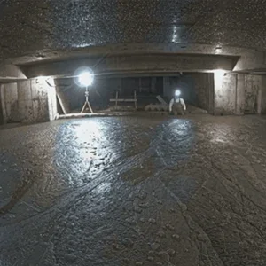
Over a total length of 1.92km, 1.27km of tunnel has been constructed by NATM along with three underground stations, with the further tunnel sections and ramps built by cut and cover (Figure 1). Work began on-site on 23 July 2001, with the tunnel drives starting in February 2002. Tunnelling was successfully completed in July 2003, and currently the installation of the watertight inner lining is on schedule to finish by the end of this year.
The Land of Upper Austria and the City of Linz are financing the project jointly. A net sum of US$105M has been earmarked for the entire project, which is scheduled to go into service at the end of 2004 after some three and a half years’ construction.
Route design
The concept will see the tram system operating mainly in a twin-track running tunnel (Figure 2). A 120m long section beneath the railway installations is the exception, where a triple-track cross-section is required to accommodate a siding (Figure 3). Two reversing loops, with a single-track standard cross-section, are included immediately in front of and behind the Central Station. The future extension of Line 3 has to be incorporated in the southern reversing loop, situated directly under the railway. To achieve these connections, two funnel-shaped enlargements – both with short, single-track connection stubs – had to be excavated within the reversing loop.
The existing buildings, the new station, the geological and hydrogeological conditions largely governed the tunnel alignment and gradient. The small radii the trams can drive are a challenge for the works and the permanent lining construction. The following parameters had to be adhered to during planning:
Legacies of the war
The area around Linz Central Station was subjected to heavy bombing in 1944-45. Altogether, it is estimated that around 20,000 bombs were dropped on the city. Experience shows that 10-15% of these were duds. Accordingly, the new tram route was subjected to a systematic evaluation of aerial photographs during the planning stage. Altogether, 13 points and 16 areas were traced where bombs were thought to be, and 77 craters established.
A catalogue of measures (surface and underground explorations) was drawn up on the basis of these studies to eliminate dangers. In areas where it was impossible to investigate from the surface, advance drill hole explorations were carried out during tunnelling. For this, two approximately 8m-14m long exploratory drills, at a distance of 3m, were undertaken near the crown at the face. One drill hole was secured with aluminium pipes (anti-magnetic) and subsequently checked by means of magnetic field probe.
Geological conditions
During subsurface investigations a wide range of different soil types were discovered. The following main soil types were classified for design purposes:
The quaternary sands and gravels were particularly relevant to the tunnelling, in addition to the made ground encountered in the crown, on account of the shallow overburden. The quaternary layers were created by the deposition of fluvial materials from the Traun or Danube on the deeply eroded tertiary sequences during the last Ice Age (Würm). These soils are heterogeneous sand-gravel mixtures, with sandy to extremely sandy medium to fine gravels, usually with a slight amount of silt. Silty-clayey fine sands and silty sands are interspersed in these non-cohesive types of soil – which vary enormously in terms of their frequency, thickness and depth.
The tertiary Oligocene layer with a semi-solid to solid consistency is located below the quaternary sands and gravels throughout the entire project area. It is made up of silty-clayey-fine sandy still water sediments consolidated by diagenetic processes. Its upper edge is characterised by the intense relief in the project area, which means that the inverts of the two reversing loops touched, and the two connection enlargements incorporated, the upper edge of the layer.
Hydrogeological conditions
The project area’s aquifer is linked to the quaternary sands and gravels, with the Oligocene layer forming the groundwater limit. The aquifer thickness varies between 6m and 9m. All sections tunnelled by mining means run through the groundwater body – with most of the invert located approximately 4m below the groundwater table.
Three measures have largely been used to lower the groundwater:
The upper edge of the Oligocene layer occasionally cropped up during excavation of the cross-section. Special measures were occasionally needed during the drives, on account of the residual water that could not be lowered by the filter wells and the invert drainage. As a result, temporary bulkheads consisting of steel sheets and struts were installed as additional support, in the event of excessively high residual water inflow in conjunction with erodible sands or very sandy gravels. This method was also applied during the construction of the gravel conduits, located well below the invert excavation, which are required to secure the groundwater stream in its final state.
The groundwater lowering system was switched off after successful ring closure of the outer lining and after the shotcrete had set to a sufficient extent. The primary shotcrete lining is designed to hold back water, although it is not watertight; temporary drainage measures were undertaken prior to the installation of inner concrete lining.
After finishing the watertight inner lining no more drainage will be undertaken. In this way the groundwater will rise to the original level.
Tunnelling works
The mined tunnelling works include the following different lengths and cross sections:
The method adopted for the tunnel drives was mainly determined by:
It was therefore imperative to ensure that the tunnelling method was designed to minimise surface settlements, while still maintaining the flexibility essential for the success of the project. Towards this end, a classical NATM drive – designed for inner urban conditions – with immediate/advance installation of the required support measures and rapid ring closure was devised and carried out. Just 4.5m beneath the railway tracks and platforms, which were in full operation during the tunnel drives, an excavation with pillar headings produced in advance, followed-up by enlargements at one or two sides, was undertaken. The standard excavation concept included as a minimum:
The following additional supporting measures were planned to ensure that the NATM was appropriately adjusted to the heterogeneous conditions:
Grouting, round gravels
During the driving operations, layers of round gravel were encountered to an unexpected and unpredictable degree, resulting in a non-cohesive flowing behaviour during excavation. Although the gravels contained layers of silt or silty sands, these intermediate cohesive layers were too thin to secure stable face conditions. After it became practically impossible to master the round gravel layers properly, even after the face was once divided into as many as 20 part-sections, the drive was switched to utilise systematic underground grouting.
Generally speaking, grouting was undertaken by means of 6m long injection lances, which were driven after every 3m-4m advance. These lances were set horizontally in the face, slightly inclined outwards along the edge of the excavation in order to improve the abutment area of the forepoling. Grouting was undertaken without pressure with a rock flour/cement mixture, 3.2:1 and 1:1 mix ratios being applied.
The grouting pattern was established on site, as well as that for the application of the other additional support measures. The encountered round gravels were cemented by the systematic grouting process, to such an extent that the drives were undertaken, with the foreseen standard and special supporting measures, safely and with minimum settlements. For the triple-track section and the southern reversing loop, located beneath the railway tracks and platforms, grouting was applied from the surface.
Monitoring
In advance of the tunnelling works, finite element calculations were carried out for the structural design of the tunnel linings and to obtain a magnitude of the ground movements. The predicted deform-ations of the shotcrete lining and surface settlements corresponded more or less to the following monitored results:
All deformations were subsiding immediately after ring closure.
For under-passing the railway and the tram tracks, trigger values were established for the allowed longitudinal and cross inclination of the settlement trough. When the daily monitoring showed that a trigger was reached, a boxing-up crew lifted the track so that tunnel excavation was not hampered.
Surface buildings have been monitored daily, paying particular attention to the structural behaviour of each building, depending on the method of construction. In a seven-storey building in the Kärntnerstraße, just 3m away from the twin-track running tunnel (Figure 4), a maximum settlement of 3mm was monitored, with no damage noted. Where the tunnel passes under a two-storey Railway workshop building (distance from foundation–tunnel crown = 2.5m) maximum settle-ments of 28mm have been monitored, some cracks in the brickwork and plaster have had to be repaired but no critical structural damage has occurred.
Permanent lining
Only watertight, reinforced permanent linings, in accordance with the guideline governing permanent lining concrete issued by the Austrian Association for Concrete and Construction Technology, have been applied. A thin (0.2mm thick) lattice-reinforced separating foil is installed between the shotcrete shell and the permanent lining in order to comply with demands on a watertight lining. This foil is to prevent the concrete of the permanent lining from drying too rapidly, resulting in an unnecessarily large degree of shrinkage.
The standard block length amounts to 10m for the twin-track running tunnel and 5m for the single-track standard cross-section in the reversing loops, on account of the small curve radii. The minimum reinforcement, according to the Austrian guideline, was increased in order to restrict cracks. The block joints are executed without joint inlay and sealed by internal water bars. The construction joints between the invert and vault are sealed by hydro-swelling water stops; an injection hose is installed to enable additional sealing injections.
Driving operations
The construction site environment and the contractual logistics call for an extremely strict control of the works undertaken both above and below ground. In some cases, unexpected geological and hydrogeological conditions called for an extremely flexible approach by all involved, to comply with the technical requirements for tunnelling as well as safety, quality and economy.
The ARGE NVD contracting JV, made up of Hinteregger & Söhne, Östu-Stettin and Dywidag, undertook an intensive risk analysis prior to work starting. In particular, the analysis took the technical marginal conditions into consideration, which have been constantly updated and evaluated.
The contractor, who called on the assistance of static engineers, geologists and geotechnicians, examined the plans put forward by the client. Any differences of opinion relating to the approach to be taken were discussed thoroughly with the client, planners and local construction supervision authority – with a jointly appointed external expert sitting in.
A reasonable balance between possible analytical proof obtained in advance and the confirmation of approaches to solutions through reference sections, in some cases accompanied by more precise investigations of details or main aspects, was achieved.
In certain cases, new ground was broken with the support of all those involved. Apart from developing new technical solutions (e.g. investigating the legacies of war), a series of tests to determine the strength development of the shotcrete, measurements relating to how train services are affected by vibrations at depth, and other measurement programmes were undertaken. These have been extremely helpful for providing direct confirmation or adjustment of the assumptions obtained in the calculations.
Outlook
Operations to construct the Linz Commuter Hub are on time, in spite of the geological problems that occurred and the substantial difficulties that had to be resolved. As things look at present, the system will be completed on, or ahead, of schedule.
Related Files
Fig 3 – Excavation sequence for the triple-track tunnel within the area of the reversing loop connections; constructed with only 1.5m-5.5m overburden
Fig 1 – Map showing the tunnelling works
Fig 2 – Standard cross section of the twin-track running tunnel