Located in the heart of Crossrail, Farringdon will become one of London’s major rail interchange stations, providing connection between three networks (Thameslink, Crossrail and London Underground). The station also has a distinguished role during the construction of Crossrail project, as it is intended to receive four earth pressure balanced tunnel boring machines (TBMs): the two Drive X TBMs, running from Royal Oak to Farringdon and the two Drive Y TBMs, running from Limmo to Farringdon.
The complete station layout will comprise two ticket halls, two platform tunnels (Eastbound – PTE and Westbound – PTW), connecting cross passages, escape and ventilation adits, two escalator inclines and two concourse tunnels that will be mainly constructed using sprayed concrete lining (SCL) tunnelling. This open face, sequential tunnelling method was preferred due to the flexibility that it provides with regards to the tunnel size and geometry. In total, approximately 1000 linear metres of SCL tunnels with cross sectional area varying from 25m2 to 110 m2 will be constructed at axis depths of approximately 30m below ground level. The majority of the tunnelling will take place within the Lambeth Group formations.
Crossrail awarded the contract to BAM Nuttall, Ferrovial Agroman and Kier (BFK) Joint Venture in 2011 that appointed Dr. Sauer & Partners (DSP) as specialist consultant on the SCL tunnelling works, providing lining design and ground support design prior to ring closure. The Employer’s SCL designer (Mott MacDonald) was responsible for the permanent works design including the composite SCL tunnel linings post-ring closure.
Tunnelling works progress
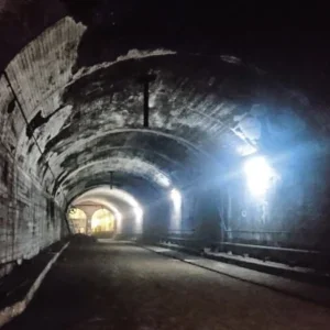
The 10.5m high by 11.5m wide platform tunnels in Farringdon station will be enlarged from the TBM pilot tunnels (6.2m radius – 7.1m considered for the cutter head) using SCL techniques. The western part of Farringdon station shown in Figure 1, comprises the lower concourse tunnel CH1 and the escalator tunnel ES1, cross passages CP1, CP2 (a&b) and CP3 (a&b), a ventilation adit (VA1), stub tunnels STW1, STW2 and STW3, platform extension tunnels PL1 and PL2, temporary connection adit CP1-CH1 and PL2RC wraparound. Access to the SCL works was provided through shafts SH-W1 and SH-W2.
Originally, the construction of the cross passage CP1 (7.2m high by 6.3m wide) was planned to finish with a temporary headwall (Figure 3), approximately 5m before the intersection with PTW, with a subsequent pause until the enlargement of PTW would take place, when the two tunnels would be connected.
According to the construction programme, shaft SH-W1 had to be backfilled with foam concrete prior to the arrival of the eastbound Drive X TBM (3/12/2013), hence, no SCL works through this shaft could take place between November 2013 and March 2014. Additionally, due to logistic reasons, lowering equipment for the probing works in the westbound platform tunnel (PTW) through shaft SH-W2 would not be possible. This potential delay called for a versatile solution that had to be designed and approved within a narrow time frame.
The role of PL2RC wraparound
The 8.85m high by 8.0m wide PL2RC wraparound was envisaged as an effective solution with regards to the aforementioned delays, providing rapid access to the TBM tunnel and allowing probing and subsequent enlargement works for PTW to commence shortly after the westbound, Drive X TBM transit. In addition, the SCL works for the enlargement of CH1 tunnel would be able to resume directly after the establishment of the connection between CP1 and PTW through PL2RC.
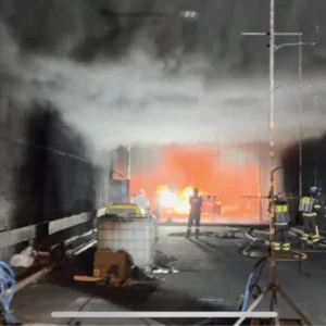
The tunnel was constructed at a depth of approximately 30m below ground level using open face excavation. A 350mm thick steel fibre reinforced, concrete primary lining was sprayed without any additional reinforcement or SCL thickening. Apart from the time and cost saving, an important Health & Safety benefit from the exclusion of steel bar reinforcement was that no working at height for its installation was required.
The geometry of PL2RC is represented in Figure 2. The construction steps related to the construction of PL2RC were the following:
- Extension of CP1 by approximately additional 5m from a temporary headwall.
- Construction of the transition from CP1 (area 36 m2) to PL2RC (area 57 m2) excavated in top heading, bench, invert steps with a 350mm thick steel fibre reinforced primary SCL.
- Construction of PL2RC excavated in top heading, bench, invert steps with a 350mm thick steel fibre reinforced primary SCL (Figure 3, left-hand side).
- Back-filling PL2RC with foam concrete for the passage of the westbound TBM.
- Passage of westbound TBM pilot tunnel through PL2RC.
- Establishment of connection between CP1 and westbound TBM by partial removal of the foam concrete backfill and the TBM segments (Figure 3, right-hand side).
- Back-filling shaft SH-W1 with foam concrete for the passage of the eastbound TBM.
- Excavation of CH1 Enlargement and concurrent probing works in the westbound TBM tunnel for the forthcoming PTW enlargement.
The 31 steps of top heading, bench and invert excavation were completed within 14 days (1/8/2014 to 15/8/2014), exhibiting an average advance rate of 1.2 m/day.
Geotechnical Description of the Farringdon station area
The geological formations in the area of Farringdon Station are the typical of London basin, with the upper strata comprising Made Ground and River Terrace Deposits overlying London Clay, the Lambeth Group Formations, Thanet Sand and the Chalk bedrock.
The following key aspects of the geology of Farringdon were considered in relation to the tunnelling works:
- Unlike the majority of the SCL tunnelling works in London, the tunnels in Farringdon would be predominantly constructed in the Lambeth Group formations (some 83 per cent of the tunnelling works), comprising stiff to very stiff over-consolidated clays with randomly distributed sandy units of variable size, continuity and pore water pressure regime.
- The presence of multiple faults inside the footprint of the station affecting the thickness, the elevation and the continuity of the soil layers.
- The thickness of the London Clay unit varied between 4m and 22m due to the geological faulting and the presence of the buried valley of the Fleet River in the area of the West Ticket Hall.
- Due to the historical water abstraction, the deep aquifer (Upnor Formation, Thanet Sand and Chalk) induced an under-drained pore water pressure effect to the overlying formations.
This geological complexity and variability in combination with the scarcity of borehole information above the alignment of PL2RC, due to the presence of the Network Rail tracks and sidings, called for a sophisticated investigation and geotechnical risk management strategy.
Dealing with geotechnical Risk
An optimised geotechnical risk management framework was integrated in the site supervision workflow, exploiting all the available information, aiming to ensure excavation stability, rapid ring closure and minimal surface settlements as required for the protection of the existing assets. This has required the presence of competent supervisory staff in the key roles of the "Senior SCL Engineer" and "Chief Geotechnical Engineer".
The assembly of all the data and the excavation and support management was embedded into the Shift Review Group (SRG) and Required Excavation and Support (RES) processes, enabling the highest possible standards of geotechnical risk management to be delivered to the project.
Three main tools were deployed in order to collect and process geotechnical data and integrate it into the cycle of risk reduction (Figure 4): in-tunnel probing (prescribed throughout the SCL works), data acquired from the tunnel excavation producing face mapping records and the 3D geological model that was updated on a daily basis allowing for geological predictions of increasing accuracy to be made.
In-tunnel probing
Optimised probing patterns ahead of the excavation face were prescribed for all the SCL works utilising dry auger drilling through a rig-mounted blow-out preventer, in order to identify potential water charged sand units that might induce instabilities during the tunnelling works.
The implementation strategy was differentiated for tunnels that would be constructed following a "top heading – bench – invert" excavation and tunnels that would be constructed following a "Pilot – Enlargement" excavation:
- The investigation for the tunnels that would be constructed following a "top heading – bench – invert" excavation, such as PL2RC, was performed ahead of the tunnel excavation, by drilling inclined and horizontal probe holes from the sealed excavation face, typically covering minimum 12m of excavation with an overlap of 3m between successive arrays.
- The investigation for the advancing enlargements of tunnels constructed following a "Pilot – Enlargement" excavation, such as platform tunnel west, was performed by drilling radial probe holes within the previously installed pilot tunnels.
The requirement of investigating minimum 3m around the outline of all the enlargements was established for all these tunnels.
All the investigation drilling was logged by a geotechnical engineer and the results were presented in longitudinal and cross sections. Two inclined probing arrays consisting of 9 probe holes, 12m long each, were designed and drilled for PL2RC.
A flow chart was developed to assist the future determination of actions based upon the probing results, which including criteria for water flow and pore-pressure control. The steps prescribed in this flow chart were followed successfully during recent encounters of water bearing Sand Lenses while probe drilling for the enlargement of PTW was carried out.
Face Mapping
The open face excavation using sprayed concrete linings provides the opportunity for detailed geological observations to be made and documented through the face mapping process.
The geological conditions in every single excavation step were being recorded and classified according to BS 5930:1999, providing a large scale ground investigation in a horizontal direction.
The encountered geology was in excellent match with the in-tunnel probing results and validated what both in-tunnel probing and 3D geological model had already predicted; that the Farringdon Fault would not be encountered during the excavation of PL2RC.
3D Geological Model
The 3D geological model for the area of Farringdon station was first developed in 2009 by the British Geological Survey (BGS) (see Aldiss et al 2012), using data from historical boreholes and site investigation carried out for Crossrail.
Due to the complexity of the geology of the station, BFK/DSP proposed to develop the model and to use it as an integral part of the site supervision workflow and provide a tool for three-dimensional illustration of the geological units and a basis for predictions for the excavation of tunnels.
Initially, the additional data from borehole drilling and excavation of shafts that was received between 2009 and 2013, were digitised and incorporated in the model by the author, resulting in a significantly updated version. Some 58 additional boreholes were was implemented in the 2013 update.
Even more significant, was the update of the model that was performed on a daily basis, making use of the continuous data derived from face mapping and probing, increasing the accuracy of the model and allowing for predictions of increasing reliability with time for future excavations.
The first prediction in Farringdon Station was performed for tunnels STW2 and PL1. At that point in time, face mapping data had not been yet used to update the model.
A prediction for PL2RC was also performed, providing a significantly improved match to the actual stratigraphy. In the area of CP1 and PL2RC very little borehole data was available, however, the data from the excavation of STW2-PL1 that was integrated in the 3D model proved sufficient to increase the accuracy of the prediction.
Geotechnical risk mapping
A mapping of the risk related to water charged sand units that could affect the SCL tunnelling works in Farringdon, was performed by the author. One map was for the design phase, referring to April 2012 when only preliminary geotechnical investigation data became available whereas mapping of the construction phase in June 2013, had a three dimensional (3D) finite element (FE) model for PL2RC in progress with additional data from ground investigation becoming available as a by-product of 25 boreholes drilled for the installation of the instrumentation and monitoring devices and the excavation of STW2-PL1. This data was used to update the 3D geological model, providing an updated mapping of the geotechnical risk.
The assumptions used for the risk mapping are listed below:
- Grade V [red] applied to either "low confidence" in the knowledge of the geological environment and/or evidence of water bearing sandy units in the tunnel horizon.
- Grade I [blue] applied to parts of the station that had already been excavated or thoroughly investigated, thus providing a high level of confidence.
- The risk was higher for large tunnels and tunnels that would be intersected by faults.
- The area east of Smithfield Fault was assigned an increased risk by default, as the pore water pressure regime was higher and tunnels were excavated within more risk-prone geological formations (the Upper Mottled Beds).
- Equally effective in-tunnel investigation (probing) would be carried out for all the structures, reducing the risk by the same amount.
The effective reduction of risk in PL2RC from Grade III in the "design phase" to Grade II in the "construction phase" was due to the updated predictions from the 3D geological model that suggested that neither Farringdon Fault nor Sand Lenses would be encountered during the excavation.
Three Dimensional Finite element modelA sophisticated non-liner 3D FE analysis was carried out by the author using ABAQUS Version 6.12 released 2011 (Dassault Systemes Simulia Company), in order to assess the capacity of the primary sprayed concrete linings (SCL), and openings of PL2RC during its construction and after the passage of the westbound TBM respectively.
The sequential excavation and lining installation were modelled using a multi-step analysis following the designed excavation and support sequences. Figure 5 provides a perspective view of the structures that comprised the 3D FE model.
Data provided by the latest update of the 3D geological model was used to simulate the anticipated geology, assuming that Farringdon Fault would not be encountered during PL2RC excavation.
Design Considerations
Approximately 130,000 linear tetrahedral solid elements were used to simulate the soil units and 9,800 linear triangular shell elements to simulate the steel fibre reinforced SCL primary lining in 46 steps of analysis.
The soil materials were modelled using the elastic-perfectly plastic Mohr-Coulomb model, taking into account the variation of stiffness with the strain level, assuming a higher strain level in the proximity of the tunnel excavation and a lower level for the remaining areas following the results of preliminary 2D FE calibration analyses performed using Phase2 finite elements package (RocScience). In addition, depth-dependent strength and stiffness parameters of the soil materials were assumed. These considerations allowed the model to capture the basic features of the more advanced constitutive models.
Two values for the at rest earth pressure coefficient were used in two models, ko=1.2 and ko=0.6. The first exhibited the highest lining stresses and was therefore used in the lining capacity checks, whereas the latter produced more realistic results in terms of in-tunnel and surface deformations and was used for the deformation predictions (similar conclusions are presented in the research performed by Gakis, Flynn, Nasekhian in 2013).
The analysis was performed assuming undrained conditions, due to the "fast" construction in comparison to the time required for consolidation of the stiff over-consolidated clays. Moreover, no groundwater pressure was applied on the SCL lining as it was considered to be permeable in the short term (prior to the installation of waterproofing layers). The soil parameters used in the FE models are listed in Table 1.
For the steel fibre reinforced SCL, the elastic-plastic "concrete damaged plasticity model" was used (Dassault Systemes Simulia 2011). The behaviour of the material was simulated as ideally elastic prior to compressive and tensile yield. The 28-days compressive strength and the residual tensile strength parameters were considered in the post-yield states. The elastic modulus for the primary lining accounted for the time dependent hardening of the steel fibre reinforced SCL (see John & Mattle 2003 and Poettler 1990). The parameters used in the FE models are listed in Table 2.
The parameters for both soil and the steel fibre reinforced SCL, were taken in accordance with the Design Statement for Temporary SCL Works (Crossrail C435 2013).
Primary lining capacity
The capacity of the SCL was checked by means of capacity limit curves (Sauer et al 1994) using the design methodology for sections under axial load and bending from the RILEM (RILEM 2003). Lining sections and structural members were checked in accordance with the Crossrail Civil Engineering Design Standards. The effect of the compensation grouting that was applied approximately 5m above the crown of the wraparound, as a mitigation measure against the induced settlements, was considered as a separate load case. The assumed area of application of the grouting pressures was divided in four panels and the pressure was applied individually on each panel and simultaneously on all panels.
Surface and in-tunnel deformation results
The Network Rail sidings, located above the alignment of CP1 and PL2RC was the main asset that had to be protected. The deformation results were extracted from the model using ko=0.6. Surface monitoring results above PL2RC were only available from the readings on the Network Rail sidings, hence, the comparison had to follow this alignment. It is evident that the 3D FE model prediction produced a very close match with the observed settlements, slightly overestimating the absolute magnitude.
A reasonable explanation would be that the stiffness of the sidings induced a "bridging effect", resulting to the targets that were positioned on them monitoring a slightly different settlement trough than the actual ground surface.
For the comparison of the in-tunnel deformations, the results obtained from the monitoring arrays that were installed in PL2RC at TM 34.400 and TM 38.300 were used. The prediction of the 3D FE model was in good agreement with the observed in-tunnel deformation.
Conclusions
The PL2RC was constructed deploying a 350mm thick steel fibre reinforced SCL primary lining without any additional reinforcement or thickening, optimising significantly the programme in Farringdon Station. An innovative design was carried out by combining a sophisticated non-linear 3D FE model that simulated accurately the steps of the sequential excavation and the geometry of the tunnel, with the 3D geological model, integrating the most recently acquired geological data.
The design check for the primary lining capacity was based on the results from the 3D FE model with ko=1.2 using capacity limit curves. The predicted in-tunnel deformations, and surface settlements due to construction of PL2RC using a 3D FE model with ko=0.6, showed a very good match with actual monitoring results.