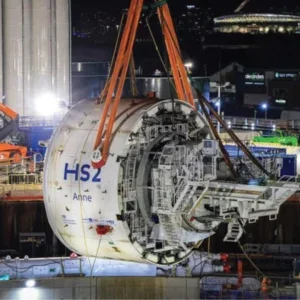
Currently under construction in The Hague, Netherlands, the Rotterdamsebaan project comprises a new 4km dual carriageway which includes two 1,860m-long tunnels of 10.15m diameter.
The TBM operated at relatively shallow depths (8-31m). To manage risk, an intensive programme of soil monitoring was required along the tunnelling corridor to measure any potential settlement of nearby structures.
The Municipality of The Hague contracted geospatial measurement specialist Fugro to oversee the monitoring process; it set the firm a challenging set of requirements given that almost half of the project is in the form of tunnelling beneath residential and industrial areas. Fugro would monitor the impact of the project on infrastructure along the tunnel alignment and give the client a continuous flow of accurate, reliable information for the enhanced control of ground risks.
The monitoring included:
- A total of 40 robotic total stations with automatic levelling in addition to 6,000 prisms.
- Geodetic control measurements (relative/absolute x,y,z values measured in millimetres).
- Asset monitoring on a 24/7 basis, with data collected from around 200 million data points.
Best Practice for Monitoring
To monitor large projects, Fugro uses multiple robotic total stations such as the Trimble S9 arranged in networks in and around the structures to be monitored. On a project of this scale, 40 or more total stations may be in use at any given time.
Total stations are strategically located to have clear views of all building and surface features monitored for deflection.
Typically, each total station is mounted on a small platform bolted to the side of a building or on a pole where it can capture a panoramic view from above the site.
However, when mounted close to businesses or residences, noise generated by frequent rotations of the total stations may be irritating to the occupants. This is not a problem with the Trimble S9, which uses MagDrive technology to provide silent operation. To connect the total stations into the reference networks, Fugro placed target prisms on buildings and chimneys that can be seen by at least two total stations. “We form networks that can be constantly measured and checked with the least squares adjustments,” explained Richard Bun, Fugro project manager and geodetic engineer.
The instruments are remotely controlled by monitoring software taking preprogrammed cyclical measurements with millimetre precision. Data analysis can identify long- and short-term trends as well as producing real-time results as the TBM passes under each segment of the tunnel corridor. Fugro has developed its own array of monitoring software called GeoRiskPortal, which has been successfully used on a variety of projects worldwide. The software can connect to numerous types of monitoring instruments, including strain gauges and extensometers.
For this project, the company wanted to include Trimble total stations for the automated monitoring. Fugro used the Trimble Precision software development kit (TPSDK) to integrate the Trimble total stations with GeoRiskPortal. The TPSDK enables software control of the instruments, allowing developers to combine the high-precision total stations with their own custom software and instrumentation.
Robotic monitoring stations were mounted on solid posts in secure enclosures along the route. These specialised self-contained units also include communications radios/modems, rain/snow hoods, and sometimes cameras. They operate as connected networks of instruments as well as common inter-visible monitoring/control points.
Stable Results
With the automated monitoring network in place, the total stations can continuously take measurements while compensating for any movement. Based on these measurements, the GeoRiskPortal software can model any movements of the surface or of structures in real-time. When working in harmony, the Trimble S9 total stations serve as silent sentinels, keeping a watchful eye on property and infrastructure situated above the tunnelling activity.
Bun noted that while there was an initial investment to modify Fugro’s software, the benefit of being able to use a wider selection of instruments – especially on a project of this scope – far outweighed the costs. In total, Fugro took around 50 million measurements before, during and after the drilling of the tunnel – all on the basis of 1,600 measurement posts attached to buildings and 4,000 in the streets.
Fugro has already expanded its capabilities on other monitoring projects and looks forward to continuing this momentum moving forward.
The monitoring project began in June 2016 and ended in March 2019.


