The tectonic collision at the edge of the Pacific that is still forming the Rocky Mountains in the US also gives California its wild and precipitous coastline; particularly south of San Francisco and onwards to Monterey and then Los Angeles, the high hills and ridges of a tumbled landscape plunge in steep slopes to the long rollers of the ocean.
The area is highly scenic, and a major attraction for tourists and travelers, particularly along the famous highway, Route One, which carries traffic on a snaking line 100m up around the spurs of the coastline. There erosion has left major outcrops and promontories. The road has featured in various Hollywood films, a famous cola advert and numerous travelogues. Water sports and the natural environment of the area, much of it protected, are additional draws to the scene.
The very landscape is also a problem at times for engineers and traffic controllers. The state highway is vulnerable to rock falls from slopes above of up to 70 degrees as weather and sea erosion dislodge material. Particularly difficult is a location known as the Devil’s Slide south of the city of Pacifica. A small town, Montara lies to the south.
The Devil’s Slide name refers to a rocky peninsula and also a short 180m stretch of the highway, though the project will by-pass roughly 5km of the existing road. Ever since it was built in the mid-1930s this section has been subject to cracking and slippage, which have caused major problems.
“About every ten years or so there is a major failure and cracking which means the road must be closed,” says California Department of Transportation (CALTRANS) principle design engineer Skip Sowko. He is project leader for the Devil’s Slide tunnel now underway, leading a team of some forty or so Caltrans staff on the project. “It is a consequence of toe erosion at the bottom of the slopes; the whole mountainside is slowly moving,” he explains, reporting that it has a factor of safety less than one.
The closures can last several months as they did in 1995 and again a couple of years ago and this has severe community and economic impact, especially as the local businesses concentrate heavily on tourism and leisure. There are few other routes in this largely state park area and so shutdown can be critical, and no more so than in a time of “credit crunch”.
Sowko says he is not aware of any fatalities from the rockslides but no one wants accidents. The slides also mean routine maintenance on the section is more expensive.
Bypass schemes, including an inland route promoted by Caltrans, have been under consideration since the 1970s.
Initially the state highway agency ruled out a tunnel option, even though there had been a small railway tunnel on the route earlier. That was closed in Prohibition times to prevent alcohol smuggling.
The proposed new tunnel route included a 1250m-long, dual-bore tunnel with a bridge at the northern end, 300m long to leap a final valley. Road approaches of 460m and 305m at the ends complete the link. These have some high retaining walls with a good area of soil nailed structure.
According to Sowko the tunnel was too expensive according to an assessment in the 1980s, but the inland over ground route was controversial because of environmental and ecological considerations. It drew considerable opposition, especially as it had climbing lanes making it wider than the usual single lane each way allowed for in the area. An injunction in 1987, from an environmental lawsuit, suspended work on the project.
“In the 1990s we had another look and the tunneling option was more attractive because of advances in technology,” Sanko says. “Relative to the increased environmental impact and land costs of the alternative it was also looking better.”
The main technological advances perhaps were the increased use of and familiarity with NATM (New Austrian Tunnelling Method) methods in the US. This was looking like the best way to construct the tunnels, which were not really long enough at 4000 feet (1231m) to justify a TBM. The route also passes through a complex mix of ground.
Geology of the region is fairly young and heavily disturbed by the tectonic activity of the region. The tunnel site lays between the well-known San Andreas Fault system, 8km to the east on the San Francisco peninsula, and another, the Seal Cove fault, just 3km out to sea.
There are two main geological layers encountered; a lower, layer of Mesozoic granodiorites predominantly, and an upper Tertiary layer of marine sedimentary rocks. On the tunnel alignment the harder rock is found in the southern half of the route, in the Montara mountains, and a mixture of claystones, siltstones, sandstones and conglomerates in the next third. This is under part of the adjacent San Pedro mountains. The remainder making up a block on the northern end is strata of the Shamrock Ranch area, also with claystone, siltstone and sandstone. The geology is typical of formations found west of the San Andreas in the Salinian Block.
The effect of the rock types is to create a variable ground “which the flexibility of NATM is well suited to getting through” says Sowko. “We have a whole slew of different rocks and you can find a mixture even in the same face. Being able to modify support metre by metre is important.”
The tunnel section of the project comprises two singlelane tubes taking each direction of traffic north and south. Each has a horseshoe profile of inner dimensions 9m (29.5ft) wide and 6.8m (22.3ft) high, which gives room for a single lane of traffic of 12ft (3.6m), sidewalks or pedestrian walkways either side of 4ft (1.2m), and shoulder areas of 8ft on one side and 2ft on the other (2.5m and 0.6m).
The twin bores are set 18m (59ft) apart with one slightly longer than the other at 4100ft (1250m) and 4150ft (1265m). Cross connections are being made at 390ft (120m) centers, which will be the core of the safety provision, allowing an unaffected tunnel to serve as the emergency and escape route for any incident in the other bore. The ten cross-passages are big enough for pedestrian escape and there is one larger in the centre of the tunnel that can allow maintenance vehicles through, although it is not big enough for large vehicles.
The project was designed and reviewed by Caltrans and consultants, and the plans and specification were completed in early 2006. Kiewit Pacific Company won a competitive tender process in November 2006 that had attracted far more interest than expected with 14 bidders. Kiewit’s lowest bid was slightly over estimates at US$ 272M but promising a shortened 1500-day time schedule.
Other contracts were let for the bridge and approach works and some smaller environmental mitigation works.
Mobilizing and preparation work was quite extensive, but tunneling began in fall 2007 with ground breaking at the south portal. Both tunnels are being driven towards the north to emerge at the southern abutment of the concrete bridges, two parallel balanced cantilever concrete arches, which were recently completed. “We were allowed no falsework in the valley for those” says Sowko.
Kiewit is using a mixture of drill-and-blast and roadheader excavation for the tunnel, with some conventional excavator digging when the face is soft enough. Blasting is only needed for the harder igneous rock and some of the sandstone, with most done by two 120-t Alpine roadheaders “which is the most cost-effective way,” says Sowko. The ATM 105 machines were purchased new for the work at just over US$ 3M each.
Face advances are made in quite short rounds of 3.3-3.9ft (1.0-1.2m), with two headings – a top and a bench. The NATM design has five categories of support with the usual shotcrete, rockbolting, spiles, grouted steel pipes and lattice girders used as required, with increasing thicknesses of shotcrete and more steel reinforcement/support for poorer ground.
“The three ‘heaviest’ categories also involve tunnel invert excavation and installation of a shotcrete invert arch, with concrete backfilling to road level” says Sowko. The lighter categories simply excavate to good rock for the road level.
Caltrans and its consultant HNTB, using borehole survey data produced and analyzed by geotechnical consultant EMI, designed support categories.
“On site the support is the contractor’s call though if it was judged too light we would intervene,” says Sowko. “Their engineers and ours meet every morning to discuss what is needed and it has gone very well with a good consensus.”
Mucking removal is with Caterpillar 730 articulated trucks loaded at the face with roadheader conveyor. Cleaning up from the face is done with a small Cat mini-excavator. Cat equipment also comprises most of the support fleet, including a D9 bulldozer, assorted loaders and for running materials up and down the tunnel, Cat skidsteer loaders.
Drill-and-blast sections use a Tamrock twin-boom rig and mucking out with Cat loaders. The relatively large tunnel profile allows conventional construction equipment to be used.
The tunnels are fairly dry. Though there is some water, it is mainly dealt with by the lead tunnel heading, which effectively acts to dewater the following faces.
“It is not much at all;” says Sowko “perhaps 150 gallons per minute (9-10 liter/s) was the largest inflow though 50 gallons is more like it.”
Spoil disposal is in a dump close to the site; this was carefully selected explains Caltrans spokesman Bob Haus “to allow landscaping and contouring.” The area is a concavity in the mountainside, which will end up convex, and is being blended into the local landscape. Some 900,000 yd3 (700,000m3) of rock will go in eventually.
So far work has gone reasonably well and the rock has only needed more of the lighter support categories than expected, although Sowko says the final 25 per cent or so currently remaining is likely to be the most difficult and demand more heavy support.
Progress has been a little slower than scheduled, which is particularly tight, and one of the winning criteria for the bid. It is nothing exceptional, says Sowko, and he says the contractor has taken some measures to accelerate, including 24/7 working.
There have been a few changes to the contract value which is currently US$ 300M, “but there is nothing outstanding and we are close to budget” says Sowko. “There is the usual range of potential claims,” he says. But he adds that relations with the contractor are good and the product “is of good quality so far.” The tunnels should be holing through in the fall this year.
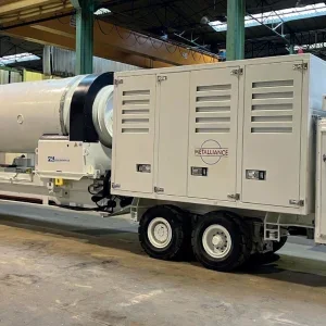
Following excavation there will be installation of an in situ lining of 14 inches (350mm) of concrete over a fleece and watertight membrane, using Ceresola formwork. Ceresola also supplied Kiewit Pacific with a gantry for erection of the steel support elements. The tunnel will be drained at the sides.
An unusual element is a texturing of the concrete lining near the portals. The portal itself projects slightly from the mountain face in a horseshoe similar to the tunnel barrel and with a cut back slope matching the mountainside.
The outside and inside concrete faces are textured using polymer form liners which as far as possible match the rock texture of the hillsides around the portals, to make an architectural blend.
Landscaping is important all round for the tunnel and the control building area on the south side. It therefore comprises a sunken basin with the building half buried to keep its profile low. The building is part of the tunnel contract.
The tunnel electrical and mechanical fittings include the now standard modern CCTV and road loop surveillance, with linear heat detectors for fire. Doors and switches are monitored telemetrically at the control center, which can display messages remotely with variable message signs at intervals.
“The monitoring is also replicated at the regional control centre,” says Sowko.
Traffic should be running on the new route line in 2011, with roughly the same 2000 vehicles/h average as on the existing highway itself.
Meanwhile the work also includes further landscaping, tidying up and external drainage. The conversion of the old section of highway into a country walk and hiking path is also part of the job once the traffic has been diverted.
Permanent lining installation in progress viewed from the Ceresola reinforcement gantry end Roadheader cutterhead Aerial view of Interstate 1 at Devil’s Slide showing the unstable slopes that are being avoided by the new tunnel The Ceresola travelling formwork before delivery to the site