Deep beneath Yorkshire’s Pennine hills, a long abandoned 189 year old canal tunnel is being painstakingly cleared of several thousand tonnes of silt and fallen rock. Few locals know even of the tunnel’s existence, and those that do question why anyone should bother to reopen it.
But this is no ordinary canal tunnel, and its £5M reinstatement no ordinary refurbishment contract. At 5.2km, Standedge Tunnel, west of Huddersfield, is Britain’s longest, highest – and one of the country’s oldest – on the canal network.
And its planned reopening by Easter next year will not only restore the canal network’s once vital east-west transpennine link, but will symbolise what owner British Waterways calls the “birth of a new canal era”.
Narrow, inaccessible and boasting an invert buried beneath several metres of silt and 3,000 tonne of rock, the concept of ever reopening the largely unlined tunnel was, for decades, described by both engineers and boating enthusiasts as “the impossible restoration”. Complexity of the task, coupled with a perceived total lack of need, all but condemned this once considerable tunnelling feat to its padlocked and steel-gated tomb.
Corridor of opportunity
But along came British Waterways 21st century style, suggesting, at the eleventh hour, that its once world leading transport network – now fast being smothered by weeds and neglect – could again perform an important communications route. But this time it would not be geared specifically to freight transport, or even boating enthusiasts, but would provide a “corridor of opportunity” along vast swathes of reopened canal routes.
“Until about 10 years ago, there was no interest in this remote and abandoned tunnel which an inward looking British Waterways saw only as a liability,” says BW’s contracts manager for the repair work David Child. “But since then there has been a sea change in attitude and political will.
“We have started looking at the wider potential of reopening routes like the Huddersfield Narrow Canal for which unblocking Standedge Tunnel at its summit is a key element.”
The idea is that, if the entire 32km length of the canal from Huddersfield to Ashton-under-Lyne near Manchester, can be refurbished and reopened, it will generate at least 400 new jobs along its route. These will be not only in new leisure development, but also in retail and commercial enterprises attracted by tourism and a waterside location.
With the Huddersfield Narrow classed as “remainder” canal, maintained only for its role as a drainage channel, BW could however contribute just £430,000 – the equivalent of its maintenance expenditure – towards the £32M needed to reopen it. But, now armed with a £29M wodge of partnership cash, mainly from English Partnerships and the Millennium Commission, BW is adding the canal to its national list of 322km of waterway restored over the next few years.
The canal was closed 56 years ago and, to reopen it now, over a quarter of the route’s 74 locks, cascading downwards either side of the tunnel, is being refurbished. To the west in Stalybridge town centre, an 800m infilled section is being re-carved out between streets and buildings. And in Huddersfield to the east, 320m of the original route – now lying buried beneath two later mills – is being unearthed as a cut and cover tunnel.
But, as during the canal’s 133 year active life, it is the highest point, Standedge Tunnel, that lies on the refurbishment project’s critical path.
Silt removal
Blasted through Pennine sandstones and mudstones during the early days of black powder dynamite, the largely unlined tunnel remains in generally good structural condition. It was after its closure in 1944 – for financial rather than engineering reasons – that most of the damage occurred.
Contractor AMCO’s prime challenge during its 18 month refurbishment contract, begun in May last year, is not the narrow 2m wide tunnel itself but what lies in it. Canal closure did not stop this 5.2km conduit acting as a natural drain, receiving both runoff and silt from the sandy peat hills above. But it did stop that silt flowing away either side down through the locks.
The result, after the tunnel was drained for repairs, is a 2m layer of fairly stiff jelly like deposit in the invert which gave AMCO an important decision to make – dig or suck.
The standard solution would have been to cut out the silt by hand or excavator, removing it from the tunnel in rail mounted skips. But the contractor, noting the fineness of the silt particles and the problems in keeping out some 30 litre/s drain water, opted instead to pump it out.
“We did not know of silt ever being pumped like this over such long distances and we had no idea if it would flow successfully,” recalls AMCO project manager Keith John. “But, after some teething problems, the system worked well and in the end we exceeded our programmed rate of clearing 200m of tunnel per week.”
Teething problems involved the use originally of a sophisticated suck and blow pump which simply lacked sufficient power. The contractor then resorted to standard sludge pumps and, by March this year, four weeks behind programme, had removed all 16,000m3 of silt.
AMCO had originally planned to work only from one end of the tunnel. But, despite adding an additional booster pump – a modified 100mm electrohydraulic suction unit – into the line about 1,000m along the tunnel, the system only worked effectively over a total 3,800m length. So the contractor was forced to install a second suction line, running from the other portal, to clear the remaining 1,400m of tunnel from the opposite end.
The £1M mucking out operation included desilting pumped effluent when it reached the tunnel portals. Here it was fed through a mobile treatment plant, boasting vibrating screens, hydrocyclones, centrifuges, plus settling tanks and holding lagoons formed in the dewatered canal bed. The end result, from a total 10,700 tonne of removed silt, was sludge cake suitable for landfill and effluent clean enough to return to the adjacent River Colne.
Beneath the silt lies further debris, some 3,000 tonne of loose rock; the result of at least four major rockfalls from the tunnel crown. But here the refurbishment team hoped to economise by taking advantage of the tunnel’s unusual profile.
Standedge was built ovoidal shaped, narrow and deep. Its narrowness was to economise on excavation and its up to 10m overall height – double the norm – was to allow increased water storage. The tunnel, located at the canal’s highest point, acts as its “summit pound”, feeding fresh water supplies down either side of the route.
The result is an average water depth of 2.5m, roughly 1m more than is required for the boats. The water level will be lowered to accommodate today’s taller craft, but only by 250mm.
So it was originally planned that some of the fallen rock beneath could be left in the tunnel and simply spread out along the invert.
Rock removal is due to start this month and John reckons that, by the time the double-winch dragline bucket is set up literally to drag the average 500mm depth of fallen rock to one of several collection points along the tunnel, it will prove more economic to take out all 3,000 tonne rather than re-profile the remainder along the invert.
The usual nightmare of difficult access to such a long, narrow and confined construction site is, at Standedge, not a problem. The reason for such an easy journey to work for both the workforce and materials is not the canal excavation itself but old rail tunnels that lie alongside and slightly above it.
Three rail tunnels were bored along the same route but only one remains in use today to carry the main transpennine route. The earlier two tunnels – the first completed in 1849 and its neighbour 22 years later – have long been abandoned and their tracks removed (see box).
But they were built using the canal tunnel itself for access via 36 short cross adits dug between the tunnels. The old rail bores have been well preserved, and Railtrack is currently considering reopening one as a dedicated new freight line. But, at present, BW’s refurbishment team can gain easy access from them to the adjacent canal tunnel.
It is near several of these cross adits that the rock debris will be piled.
It will then be routed up conveyors laid in the adits themselves to discharge into lorries using one of the old rail tunnels.
The month-long setback removing the silt is not critical as follow on permanent repairs, inside the cleaned up tunnel, have been accelerated to keep the overall contract on schedule . And AMCO still plans to finish all tunnel repairs by late summer, four months ahead of the contract’s official December end date.
Tunnel strengthening
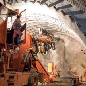
While silt and rock are removed from the invert, repairing and strengthening the tunnel crown and sides can continue at the same time using a scaffolded work platform erected mid-height along the route. The 45% of the tunnel that is already lined with either masonry or brickwork generally requires only pointing, but the remaining 2,860m of unlined rock needs varying degrees of strengthening.
Soft shale bands in the sandstone and mudstone bedrock have deteriorated, contributing to the rock falls and leaving weak zones along both crown and tunnel sides.
The worst sections, totalling 2,000m, need strengthening with 2m long stainless steel rock bolts and a 100mm thick sprayed shotcrete lining reinforced with stainless steel fibres. Other areas need rock bolts and steel mesh, with the remainder strengthened only by bolts.
Because of the tunnel’s distinct inaccessibility for future repairs, British Waterways requested a 125 year design life on all strengthening work. This means only longer life stainless steel is used for mesh, reinforcement and all 5,000 rock bolts.
Again, the conveniently empty and adjacent rail tunnels can be used for all materials access; with the numerous cross adits allowing multiple work areas.
So, ironically, it is the railway – the very medium that led to the canal’s early death last century as a commercial transport route – that today contributes significantly to its rebirth for the 21st century.
Related Files
Location map
Route