Anyone who has survived a long haul fight to Sydney only to endure another couple of hours stuck in a traffic jam on arrival should spare a thought for residents, commuters and hauliers who do daily battle with road congestion.
As a case in point, the M5 East, which links the central business district (CBD), Sydney airport and Port Botany to south-west Sydney, Canberra and Melbourne had a design capacity of 77,000 vehicles per day when it opened in 2001. That capacity was exceeded within just six months and daily volumes now top 100,000.
Sydney’s road arteries are clogged, with congestion currently costing the NSW economy an estimated AUD 5.1bn (USD 4bn) a year, rising to a potential AUD 8.6bn (USD 6.7bn) by 2020.
The city’s population is set to rise by 1.6 million over the next 20 years, with most of the population increase predicted to occur in Western Sydney, an area that has already grown to become the third largest economy in Australia.
Unless major infrastructure changes are implemented, NSW’s capital city could grind to a halt.
That’s the compelling motive for the NSW government’s investment of billions of dollars in the largest urban transport and infrastructure programme in its history, a programme that Duncan Gay, NSW’s Minister for Roads & Freight, calls "a game changing project for Sydney and for the NSW economy".
The infrastructure improvements will include some rail links but as the city’s road network accounts for 93 per cent of passenger journeys and 86 per cent of freight movement (freight and logistics are worth AUD 58bn to the NSW economy annually) the motorway system is being expanded.
In 2012 the government committed to building WestConnex, an integrated project to expand capacity and ease traffic flow on the existing M4 and M5 corridors and improve links to Sydney airport and the Port Botany area. Ultimately WestConnex will link the two motorways together, thus joining the east and west of the city for the first time.
The estimated AUD 11 to 11.5bn (USD 8.6 to 8.9bn) capital cost of the entire WestConnex programme will be funded in part by tolls but also by a AUD 1.8bn (USD 1.4bn) contribution from the NSW government and AUD 1.5bn (USD 1.2bn) from the Australian government.
In addition, the Australian government is providing a concessional loan of up to AUD 2bn (USD 1.6bn).
The decade-long construction project, which is still at a very early planning and design phase, will total 33km of traffic signal-free motorway.
And, in order to minimise the need for property acquisition and disruption to communities along the route in this densely urbanised area, two-thirds of it will be underground – WestConnex will include up to 22km of tunnels.
The development is being steered by the WestConnex Delivery Authority, which was established by the NSW government to deliver the programme of works for Roads & Maritime, and is being delivered through a series of projects in three stages:
Stage one is the M4 Parramatta to Haberfield section, which will be in two phases, with the M4 widening due to be complete in 2017 and the M4 East in 2019 (the M4 currently connects the Blue Mountains in the west with Parramatta Road in the east).
Stage two is the New M5 Beverley Hills to St Peter’s section, which, thanks to the Australian government’s AUD 2bn concessional loan, has been brought forward by more than 12 months.
Subject to planning approval, this is also scheduled for completion in 2019.
Stage three is the M4/M5 link, joining the M4 and M5 from Haberfield to St Peter’s. Detailed design and construction work is scheduled to start in late 2018 with completion expected in 2023.
Stage one: M4 and M4 East
Planning approval for stage one, the widening of the M4, was granted and preparatory work, including final geotechnical work and investigation of utilities was completed before site work began in February (geotechnical investigations are being carried out at around 100 locations along the WestConnex corridor in order to inform the design and construct tender process and the Environmental Impact Statement). The design and construction of this 7.5km section of WestConnex has been contracted to the Rizzani De Eccher Leighton joint venture.
Work on the M4 East section will include two three-lane tunnels in each direction under the Parramatta Road corridor to Parramatta Road and City West Link, Haberfield. The tunnels will be about 5km in length, with additional length required for the ramps in each direction.
Moving the motorway underground will enable "urban revitalisation and regeneration" of the area at surface level, said the WestConnex Delivery Authority, which anticipates the development of different housing types, plus business and retail investment along Parramatta Road.
It also expects the tunnels "will provide a general improvement to local air quality on surface roads where traffic numbers are reduced".
Design development is ongoing and is aimed at optimising the function and cost of the M4 East project and also mitigating, or preventing potential environmental impacts.
Ongoing design options include optimising the alignment of the tunnels to avoid specific geotechnical constraints such as palaeovalleys and to provide appropriate gradients for heavy vehicles; and selecting appropriate sites for tunnel portals, ventilation stacks and possible air intakes along the alignment.
The most recent road tunnels constructed in Sydney – including the M5 East tunnel, the Cross City Tunnel and the Lane Cove tunnel have all been designed to avoid portal emissions and tunnel air is primarily discharged from ventilation stacks.
Once operational, the tunnel ventilation system is expected to be the main consumer of energy within Stage one of the project.
The WestConnex Delivery Authority says an "iterative design process" would investigate means to reduce energy consumption as much as possible but extrapolating data from existing tunnels has led to the conclusion that the M4 East tunnels have the potential to consume anywhere between 11,200 and 54,000MWh per year, depending on ventilation system efficiencies.
These figures equate to the energy consumption of 1,800- 8,500 households.
Thiess Samsung John Holland JV (Thiess, Samsung C&T Corporation and John Holland) have been appointed as contractor and designer for the M4 East. An Environmental Impact Statement (EIS) is being displayed and community comment invited.
The planning approval decision is expected late this year and major work should start mid-2016. Tunnelling activity is expected to be undertaken on a 24-hour basis.
Stage two: New M5
The first part of stage two, the New M5, has also recently been granted planning approval and will see improvements to the King George’s Road Interchange. Construction on this upgrade will start this summer and will clear the way for the New M5 tunnel.
The New M5 will run from the existing M5 East corridor at Beverley Hills via tunnels to St Peter’s, providing improved access to the airport, south Sydney and Port Botany precincts.
New twin tunnels will be "higher, wider and flatter" than the existing M5 East tunnels (the steep gradient in the westbound tunnels slows travel speeds and worsens congestion and greenhouse gas emissions) and will more than double capacity.
Once the New M5 main tunnels are open it will be possible to undertake a programme of refurbishment and equipment upgrades on the existing M5 East tunnels.
The government is working with the private sector to develop the best design and the precise location of where the tunnels will emerge and where the exhaust stacks will be won’t be available until late this year when the WestConnex Delivery Authority lodges its EIS.
However, the location of the western portals will be somewhere between King George’s Road and Bexley Road, while the eastern portals at St Peter’s will be in the vicinity of land generally bounded by the Prince’s Highway, Campbell Road, Burrows Road and Canal Road.
Tunnel stubs will be constructed to allow for the future connection to Stage three of the WestConnex programme.
The current thinking is that the 9km tunnels will have a vehicle clearance of 5.3m, an improvement on the 4.6m in the existing M5 East tunnels, and gradients will generally be limited to 4 per cent, compared with up to 8 per cent.
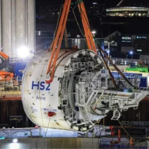
Tunnel depth will vary depending on geological constraints and operational design requirements (such as road gradient). Construction of the tunnels will be carried out around the clock, seven days a week and road headers and/ or TBMs may be used for the deeper parts of the alignment, while cut and cover construction methods may be employed at shallower sections, such as the tunnel portals.
Other excavation activities are likely to include the creation of cross passages and caverns or shafts for other support infrastructure.
On and off ramps at each end of the project will include sections of tunnel to provide direct connections from the main motorway tunnels to the M5 East motorway and the proposed St Peter’s interchange.
Spoil from tunnel excavations is expected to be largely uncontaminated and its removal will be managed in accordance with WestConnex Delivery Authority’s management strategy, which is in development.
The EIS will provide further details on the estimated volume of spoil and the preference is for it to be re-used in other construction projects wherever possible – these could include development sites that need engineered fill, or other land rehabilitation projects.
The Alexandria Landfill site has been earmarked to support the tunnel and road construction activities required for the St Peter’s Interchange.
The tunnel carriageways will be built to accommodate three-lane operation and will boast more efficient and modern tunnel ventilation systems, which will ensure "visibly clean air quality".
The NSW government has appointed an Advisory Committee on Tunnel Air Quality to review current national and international best practice. A detailed air quality study will be included in the New M5 EIS and will assess air quality impacts from the construction and operation phases of the project.
The ventilation system will be designed and operated to meet stringent in-tunnel, local and regional air quality criteria imposed by the Department of Planning and Environment. As well as ensuring the air quality within the tunnel is maintained, it will ensure the tunnel has a negligible impact on local and regional air quality.
The locations of the ventilation facilities will be subject to further design development but they are likely to be located close to the tunnel exit portals.
This is deemed to be the most cost effective and energy efficient location given the reduced requirement for pushing tunnel air in the opposite direction to traffic flow.
Having said that, management of in-tunnel air quality may necessitate the construction of ventilation facilities at intermediate locations along the main alignment tunnels. WestConnex Delivery Authority is installing air quality monitoring stations to establish additional baseline data.
The choice of portal location, together with the tunnel alignment to St Peter’s and the detailed design, will be proposed by the contractors tendering for the project.
A shortlist for the design and construction of the New M5 was announced in November 2014 and tenders were invited shortly after.
The five consortia bidding for the contract are: Lend Lease Acciona joint venture; Leighton Dragados Samsung joint venture; Salini Impregilo; Strabag: and TunneLink (consisting of Ferrovial Agroman, Ghella and McConnell Dowell Constructors).
The preferred bidders were due to be announced in summer as Tunnels and Tunnelling went to press.
Stage three: M4/M5 link
Stage three, the M4/M5 link, will deliver a motorway tunnel with three lanes in each direction, joining the M4 and M5 corridors (Stages one and two).
The indicative route has already been realigned as the WestConnex Delivery Authority has factored in a possible northern extension of WestConnex towards ANZAC Bridge.
This would tie in with Infrastructure NSW’s proposal to build a new Sydney harbour tunnel – the Western Harbour tunnel – which would run from Balmain to Lane Cove and link with the M2.
The harbour tunnel project is a good decade away but the chairman of Infrastructure NSW, Graham Bradley, is keen to see the plans progress and for the link with WestConnex to be established.
"It’s a 10-year plus project away but it could well be an adjunct to WestConnex that will have an impact on how it might affect the interconnection here with the city," he said.
The M4/M5 tunnel, which has lengthened by 1km to 8km as a result of the realignment, will now follow the route of the existing City West Link Road before turning south to St Peter’s.
"This new alignment will continue to support the reduction of traffic on Parramatta Road, enabling urban renewal, and in addition will support the NSW government’s proposed future Western Harbour tunnel and will help provide a much needed western bypass of the CBD (central business district)," said Duncan Gay.
Again, said Gay, "the government is committed to delivering wider, higher and flatter road tunnels for Sydney, designed to world’s best practice, avoiding mistakes of the past".
"Overheight tunnel incidents can cause considerable damage to Sydney’s tunnel infrastructure, such as lights, fans and sprinkler systems and have a massive impact on traffic flows, inconveniencing thousands of motorists," said a WestConnex Delivery Authority spokesperson.
"Learning from the past, tunnel clearance will be 5.3m rather than 4.6m."
As with the New M5 tunnels, the M4/ M5 link tunnels will also be built at a low gradient.
"By 2031 the M4/M5 link is expected to carry 120,000 trips each day, about 40 per cent of daily WestConnex trips," said the spokesperson. "Unless Stage three is built these trips will be borne by surface roads in the inner west and across the Sydney road network"
Geology in the New M5 project corridor
The western areas of the project are relatively flat and low-lying, with gentle undulating hills ranging from 30-40m. The topography of the project corridor near the confluence of Wolli creek and the cooks river is relatively flat and low-lying (5-10m) and gradually declines towards Botany Bay.
The geology along the project corridor relates to the Sydney Basin stratigraphy, with Ashfield shale (part of the Wianamatta Group) overlying Hawkesbury sandstone. The Mittagong Formation separates the Ashield shale from the underlying Hawkesbury sandstone over much of the Sydney Basin.
Ashfield shale corresponds to ridgelines within the project corridor and is present largely in the west and to the north of Sydney airport.
The Ashfield shale is estimated to be around 60-70m in thickness and consists of siltstone and laminate sub-group units.
The Mittagong Formation comprises fine-grained sandstone and siltstone. The thickness of the formation is variable but is generally less than 10m.
Hawkesbury sandstone is present towards the Cooks river within the project corridor, in areas of steeper topography. Hawkesbury sandstone is a medium to coarse-grained quartz sandstone deposited in beds of 1-3m thick.
Hawkesbury sandstone and Ashfield shale are overlain by unconsolidated Quaternary sediments in areas adjacent to the cooks river and Alexandra canal.
Sections of the project corridor in the vicinity of Tempe and St Peter’s are understood to be near to the location of historical brick pits, quarries and disposal facilities, which are underlain by pleistocene-aged Botany sands, comprising aeolian sand and dune deposit with lenses of peat and clay.


